
This page is part of © FOTW Flags Of The World website
Lichtenvoorde (The Netherlands)
Gelderland province
Last modified: 2003-07-18 by jarig bakker
Keywords: lichtenvoorde |
Links: FOTW homepage |
search |
disclaimer and copyright |
write us |
mirrors
 Shipmate Flagchart : http://www.shipmate.nl/flags.htm
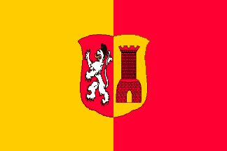
adopted 30 Oct 1969.
See also:
Lichtenvoorde municipality
Number of inhabitants (1 Jan 2003): 19.446; area: 73,83 km². Settlements:
Lichtenvoorde (seat), Harreveld, Lievelde, Vragender, Zieuwent.
Lichtenvoorde is a municipality in the Achterhoek, East Gelderland.
This area was already inhabited 5000 years ago. In the 10the century AD
it became a 'heerlijkheid' - 'lordship', which was inherited by
the Polish prince Adam Czartorisky, who sold it to Prince Willem V in 1776.
The old flag was divided vertically Yellow - Red and in the center the
municipal CoA, crowned; it was adopted 1958, after it had been used for
several years unofficially. The castle on the CoA reminds of the former
castle Lichtenvoorde.
Jarig Bakker, 4 October 1999