
Last modified: 2003-07-18 by jarig bakker
Keywords: sittard | geleen |
Links: FOTW homepage |
search |
disclaimer and copyright |
write us |
mirrors
 Shipmate Flagchart : http://www.shipmate.nl/flags.htm
Shipmate Flagchart : http://www.shipmate.nl/flags.htm
Sittard with it's 50.000 inhabitants is situated in the heart of Limburg
province, the narrowest part of the province, sharing a border with Germany
and Belgium being only a few kilometers away. The (former) municipality
of Sittard itself is the result of a merger of the former municipalities
of Sittard, Limbricht and Munstergeleen (1982) and included the villages
of Guttecoven, Einighausen and Windraak. In 1942 the then German municipality
of Broeksittard was handed over to Sittard by the German occupiers. In
1157 the name Sittard appears in documents, and is probably derived from
the word "de Siter", which is a fertile piece of land between Geleenbeek
and de Rode Beek. In 1243 Sittard became a City. In 1677 Sittard was destroyed
completely. In 1400 Sittard together with Born and Susteren, was sold to
the Duke of Gulik, under who's power it remained until 1794, when the French
took over. In 1814 Sittard became part of the "Verenigd Koninkrijk der
Nederlanden", but this only lasted until 1830. Between 1830 and 1839 is
was part of the new state of Belgium, and after that it became a permanent
part of the Netherlands.
The CoA was designed in 1982 (at the merger). In gold with a curly
cross in sable, in the base gules three chevronny or. The shield is covered
with a crown of three leaves or. The base is a reminder of the former municipality
of Limbricht.
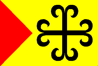
The flag is described as : Field in yellow with a red Pennon a third
of the length of the flag, on the fly a black curly cross, of which the
height is 4/5 of the height of the flag.
 Shipmate Flagchart : http://www.shipmate.nl/flags.htm
Geleen is c. 20 km north of Maastricht, one of the old mining centers
in the region. After the mines were closed the chemical industries of DSM
offered employment.
The flag was unofficially used until it was officially adopted in (?),
derived from the CoA.
Jarig Bakker, 26 November 1999
Geleen is the result of a merger of 3 villages (Oud-Geleen, Lutterade
and Krawinkel), after 1920 these villages started growing in towards each
other, and when the State Mine Maurits opened (in 1928) this accelerated.
After the State Mine closed, DSM (Dutch State Mines) situated a very large
chemical complex here. The municipal borders were adjusted in 1982, so
that all DSM property was within the municipal borders.
Franc Van Diest, 25 February 2001
 Shipmate Flagchart : http://www.shipmate.nl/flags.htm
Born is northwest of Sittard on the Maas river. It was built around
the castle of the count de Noidans (built 1647-1666), where according to
tradition one can find the throne of king Zwentibold or Sanderbout. Zwentibold
was the illegal son of Arnulf (c. 850-900), king of Germany, who spent
some time in Born before he was elected king of Lorraine (895-900). He
died in the battle of Susteren (13-8-900).
The colors of the flag are the Gelderland
colors upside-down; Born used to be partly of Gulik, partly of Gelre.
Jarig Bakker, 23 November 1999
![[Munstergeleen flag]](../images/n/nl-li_mg.gif) Shipmate Flagchart : http://www.shipmate.nl/flags.htm
Shipmate Flagchart : http://www.shipmate.nl/flags.htm
Flagdescription: Two equally wide horizontal stripes of blue and red;
on the blue stripe charged with a white sword; on the red stripe with white
plyers; and a yellow hoist-triangle with a black snakehead-cross.
This flag was adopted by municipal resolution on 17 Apr 1962. It is
derived from the municipal arms; the white sword symbolizes Saint Pancratius,
and the white plyers Saint Apollonia. The snakehead-cross is taken from
the Sittard CoA.
Source: Sierksma's Nederlands Vlaggenboek [sie62].